Log in
All resources
Create a design
338 Free Artworks of 1800 Maps
maps from the earth and its inhabitants, vol. xi
algeria in the 1800s
bibliothèque nationale de france
early works to 1800
natural history
maps by john cary
john cary
voyages and travels
smithsonian libraries
description and travel
old maps of former departments of france
maps from gallica
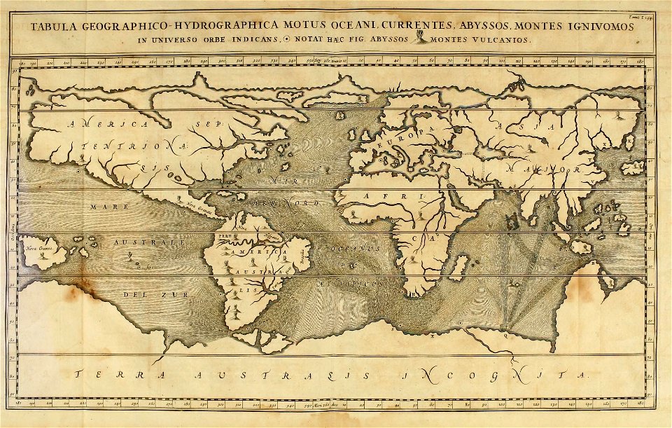
19th-century double hemisphere world maps
1800s maps of the world
drawings by johan frederik clemens in the statens museum for kunst
gray wash
barcelona in the 1800s
maps by juan lopez
lawrence h. slaughter collection of english maps, charts, globes, books and atlases
pre-raphaelite brotherhood
maps by john cary
1801 maps
maps by john cary
1801 maps
bibliothèque nationale de france
guillaume sanson
french-language maps
ambroise tardieu
eran laor cartographic collection
giovanni maria cassini
eran laor cartographic collection
giovanni maria cassini
eran laor cartographic collection
william henry toms
everett d. graff collection of western americana
st. louis, missouri in the 1800s
maps by alexis-hubert jaillot
maps by guillaume sanson
territorium argentoratense (1652 map)
bibliothèque nationale de france
maps from the earth and its inhabitants, vol. xi
algeria in the 1800s
maps from the earth and its inhabitants, vol. xi
algeria in the 1800s
maps from the earth and its inhabitants, vol. xi
algeria in the 1800s
maps by john cary
1801 maps
maps by jodocus hondius
1590s maps of the world
maps from the earth and its inhabitants, vol. xi
algeria in the 1800s
maps from the earth and its inhabitants, vol. xi
algeria in the 1800s
maps from the earth and its inhabitants, vol. xi
algeria in the 1800s
maps from the earth and its inhabitants, vol. xi
algeria in the 1800s
maps from the earth and its inhabitants, vol. xi
algeria in the 1800s
map collection of leibniz-institut für länderkunde
19th-century maps of the bosphorus
old maps of the rhineland
maps by gerard de jode
territorium argentoratense (1652 map)
context files from gallica
maps from the earth and its inhabitants, vol. xi
algeria in the 1800s
1800s maps of egypt
maps by john cary
map of italy by guillaume delisle (1700)
1700 maps of italy
maps from the earth and its inhabitants, vol. xi
algeria in the 1800s
maps from the earth and its inhabitants, vol. xi
algeria in the 1800s
maps from the earth and its inhabitants, vol. xi
algeria in the 1800s
maps from the earth and its inhabitants, vol. xi
algeria in the 1800s
turgot map of paris – derivative files
rue saint-nicaise (paris)
voyage de découvertes aux terres australes
old maps of australia
maps from the earth and its inhabitants, vol. xi
algeria in the 1800s
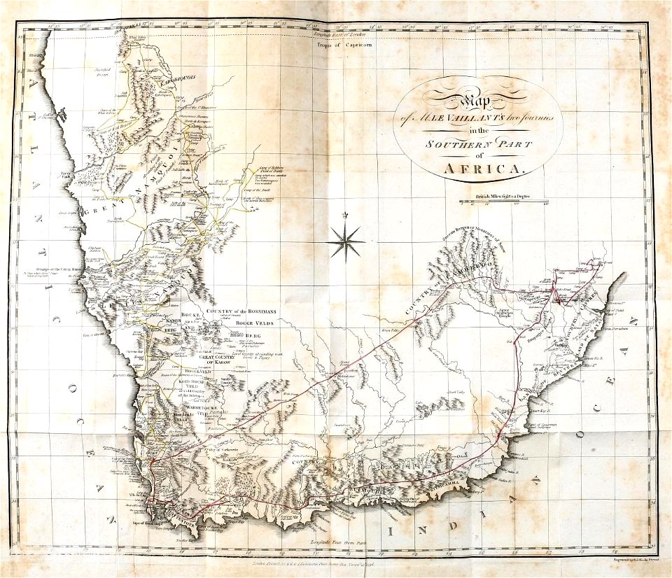
a voyage to abyssinia, and travels into the interior of that country, executed under the orders of the british government in the years 1809 & 1810
john outhett
maps from the earth and its inhabitants, vol. xi
algeria in the 1800s
maps from the earth and its inhabitants, vol. xi
algeria in the 1800s
maps from the earth and its inhabitants, vol. xi
algeria in the 1800s
the gazetteer of scotland (1838)
william home lizars
1800s maps of czechia
maps by john cary
1804 maps of europe
maps by john cary
maps from the earth and its inhabitants, vol. xi
algeria in the 1800s
maps from the earth and its inhabitants, vol. xi
algeria in the 1800s
maps from the earth and its inhabitants, vol. xi
algeria in the 1800s
maps from the earth and its inhabitants, vol. xi
algeria in the 1800s
a voyage to abyssinia, and travels into the interior of that country, executed under the orders of the british government in the years 1809 & 1810
john outhett
eran laor cartographic collection
william henry toms
science
geology
maps from the earth and its inhabitants, vol. xi
algeria in the 1800s
maps from the earth and its inhabitants, vol. xi
algeria in the 1800s
maps from the earth and its inhabitants, vol. xi
algeria in the 1800s
antoine-françois tardieu
maps from gallica
nude drawings in the rijksmuseum amsterdam
drawings of nude sitting male humans
a voyage to abyssinia, and travels into the interior of that country, executed under the orders of the british government in the years 1809 & 1810
john outhett
maps from the earth and its inhabitants, vol. xi
algeria in the 1800s
science
geology
maps of the course of the rhine by guillaume sanson
bibliothèque nationale de france
1800s maps of denmark
1801 maps of europe
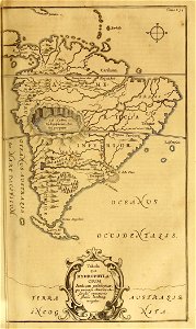
south america in the 1800s
realism
paleontology
maps
st thomas's church, monmouth
welsh landscape collection
antoine-françois tardieu
maps from gallica
the gazetteer of scotland (1838)
edinburgh in art
prints by johan frederik clemens in the statens museum for kunst
engraving
antoine-françois tardieu
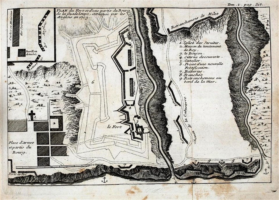
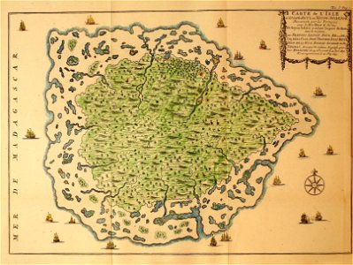
1800s maps of hispaniola
antoine-françois tardieu
1800s maps of hispaniola
maps from the earth and its inhabitants, vol. xi
algeria in the 1800s
maps from the earth and its inhabitants, vol. xi
algeria in the 1800s
territorium argentoratense (1652 map)
bibliothèque nationale de france
maps of haguenau
carolus allard
maps from gallica
baroque
19th-century maps of the isle of wight
william price
bibliothèque nationale de france
maps by thomas kitchin
maps by john cary
1801 maps
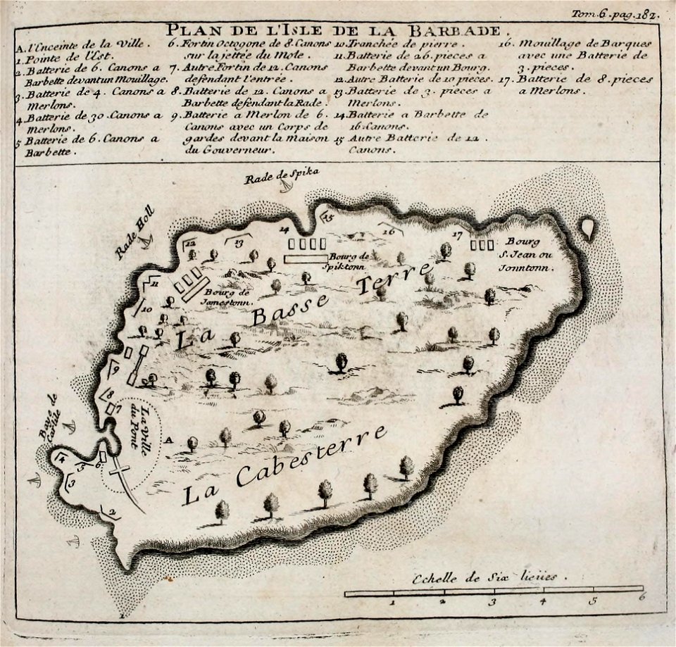
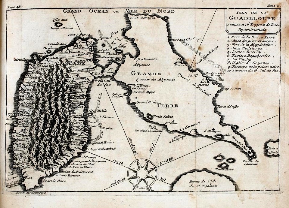
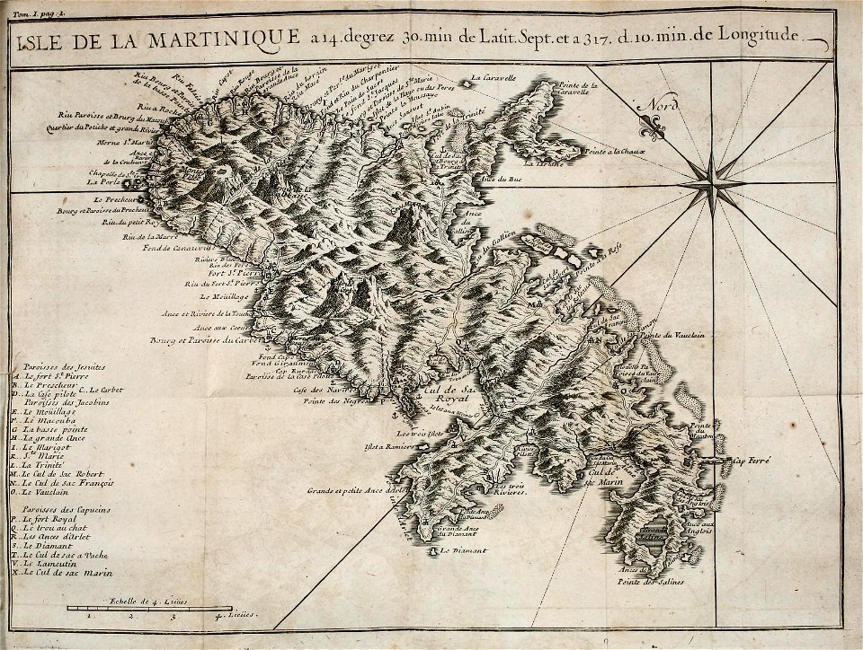
1800s maps of the caribbean
charles picquet
french
maps
french
maps
french
maps
french
maps
french
maps
antoine-françois tardieu
1800s maps of hispaniola
french
maps
french
maps
voyages and travels to india, ceylon, the red sea, abyssinia, and egypt, vol. 3
henry cooper (engraver)
narrative of a five years' expedition (1806)
romanticism,fairy painting
islands
maps
satirical prints in the british museum
realism
haarlem in the 19th century
haarlemmerhout
travel
maps
satirical prints in the british museum
realism
1800s maps of the americas
maps by john cary
bibliothèque nationale de france
ambroise tardieu
1805 maps of the united states
maps by john cary
voyages and travels to india, ceylon, the red sea, abyssinia, and egypt, vol. 3
james tyrer
voyages and travels to india, ceylon, the red sea, abyssinia, and egypt, vol. 3
henry cooper (engraver)
letters from portugal and spain (1809)
a coruña in the 19th century
201 - 300 of 338
Next page
/ 4

![Topographical Map of the Department of Montenotte / Written by the care of Mr. Count de Chabrol Prefect. Scale of 10,000 Meters [=Om. 050; 1: 200,000]; Drawn by Cecchi, geographer, between 1806 and 1812](https://cdn.creazilla.com/illustrations/10000562582/topographical-map-of-the-department-of-montenotte-written-by-the-care-of-mr-count-de-chabrol-prefect-scale-of-10000-meters-om-050-1-200000-drawn-by-cecchi-geographer-between-1806-and-1812-sm.webp)


![Map of Finland / drawn up by P. Lapie,...; Engraved by Tardieu senior... Scales of 12 Myriameters [=0m. 047], of 25 Common Leagues of France [=0m. 054]; of 12 Miles of Finland, 1808](https://cdn.creazilla.com/illustrations/10001521238/map-of-finland-drawn-up-by-p-lapie-engraved-by-tardieu-senior-scales-of-12-myriameters-0m-047-of-25-common-leagues-of-france-0m-054-of-12-miles-of-finland-1808-sm.webp)


![Map of Finland / drawn up by P. Lapie, cap[itaine], ing[ieur], geog[raphe]; engraved by Tardieu aïné; written by Giraldon, 1808](https://cdn.creazilla.com/illustrations/10001359680/map-of-finland-drawn-up-by-p-lapie-capitaine-ingieur-geographe-engraved-by-tardieu-an-written-by-giraldon-1808-md.jpg)


![A new chart of the isle of Wight [Bognor Regis - Durlston head], William Price, 1800](https://cdn.creazilla.com/illustrations/10000679901/a-new-chart-of-the-isle-of-wight-bognor-regis-durlston-head-william-price-1800-md.jpg)